


Topcon's MAGNET Vison brings a whole new reality to laying out project markers on a building site, writes David Chadwick
The world of videogaming was never really for me. I think I lost interest back when Space Invaders was starting to evolve into more than just a simple 'shoot 'em up'. I am amazed, however, by the vast size and appeal of the industry and the quality of the graphics, and how they expanded into the realm of Virtual Reality (VR) and Augmented Reality (AR). AR headsets and glasses are now also a phenomenally handy tool on the building site, particularly in the initial layout out stage.
The traditional method of doing this is to take a map of the terrain involved - perhaps a 2D printout - with the outline of the various building plots marked on it, and the positions selected for the stakes to be hammered in. Surveying equipment is then set up to locate the position for each of the stakes and the junior member of the team (there has to be at least two people involved) makes their mark.
Although the surveying technology has improved by leaps and bounds, the resulting accuracy can still be affected by something as basic as the weather on the day of the survey.
There is a stark difference between the way a lot of companies still handle all of the surveying tasks on a building site and what is now possible using the latest software tools, supported by powerful augmented reality equipment. With virtual images of both the terrain and the salient features of a 3D building model or project site displayed on the lenses of an AR headset - and the latest devices look more like thickset sunglasses than snorkling goggles - controlled by handheld smartphone or laptop device, a surveyor can move quickly from point to point indicated on the model, and precisely position each of his stakes with a very high degree of accuracy. No heavy equipment to set up, no requirement for a partner to facilitate the triangulation required on each leg, and no ambiguity on the classification of each marker.
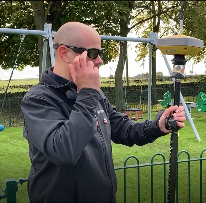
TopCon Site Layout Using AR for on-site layout is just one of a number of site surveying tools developed by Topcon to help bring traditionally time-consuming and labour intensive practices right up to date. At the core of Topcon's offering is their software application, MAGNET Construct, which allows for the integration of a pair of AR glasses. Manufactured by Vuzix, they can be integrated with either iOS and Android devices.
The Vuzix Blade smart glasses not only provide augmented reality positional information for stake out and QA processes, but give access to all of the other functions and processes that you would expect with AR connected technology. This includes access to emails, taking site pictures, live streaming video or just answering your phone calls. Utilising the AR glasses also means that you can just leave your phone in your pocket, surely a real boon to improving on-site health and safety.
Topcon consider AR to be an emerging technology and so instead of developing an app around a specific range of AR devices, they have chosen to produce one that will work with both current and future generations of augmented reality technology. The Vuzix Blade AR glasses, which are lightweight and hands-free, are currently an ideal tool for surveyors who want to take coordination information onto the project site, aggregating data from multiple sources. Coordinating the integration of the project information is MAGNET Enterprise, Topcon's cloud based file management and transfer solution, which is already integrated with Autodesk's surveying platform and its proprietary Point Layout solution, as well as BIM 360 Docs and Bentley's ProjectWise.
Topcon Magnet The Topcon on-site layout tool is used in conjunction with MAGNET Construct 4.1, the mobile technology that gives surveyors a full 2D or 3D layout in the palm of their hand. MAGNET Construct is a cloud connected application that provides data for positioning layout, and also for other as-built surveying applications, using robotic and GNSS devices. It can be used to control robotic total stations, GNSS receivers and Layout Navigator. The mobile app provides a streamlined workflow with graphical real-time positioning to any point, line, surface or feature on the project site. It can also combine optical and GNSS survey data to create hybrid models, and is highly effective as a data collection tool. It provides full communication facilities for surveying teams, allowing them to share files using normal email functionality of through MAGNET Enterprise.
The Vuzix Blade glasses are state-of-the-art, and include an autofocusing HD camera, stereo speakers in the temples, and noise cancelling microphones, both Wi-Fi and Bluetooth, full colour in one eye, and come with full UV protection and safety certification.
Leveraging Magnet Field Whilst MAGNET Vision might be considered one of the end users of field data, the software that collects and coordinates the data in the first place is equally compelling. MAGNET Field, TopCon's topographical surveying application, uses land surveying tools to collect land positioning data - points, lines, areas, cross sections, surfaces, and other data - to create map or measurement views within its Topographical Survey function. The application can handle a vast number of imports from CAD, GIS and other data sources, and use them to calculate surface levels and contours, and to automatically create accurate Digital Terrain Models.
MAGNET Field also creates the layout data - the Stake Points - in whatever method of layout or stakeout surveyors need: Point, Lines, Offsets, Roads, Surface, Slope, and Real-Time Roads etc. Relvant data such as road stakeout information able to be presented on a single screen as you stake anywhere along the road design in real-time, increasing productivity.
GIS mapping, and aerial imagery from Microsoft's Bing maps combines the DTM models with satellite image backgrounds, which can then be merged with projected civil engineering or structural building projects. MAGNET Field can provide surveyors with a full visual site context, and a full picture of the project, turning on-site layout into child's play.